Thornburgh Resort Development

SunsetMountain

FAQs on the Thornburgh
Resort Development

RECOA owners have asked questions about the Thornburgh Resort development being built near the Ridge at Eagle Crest.  This document attempts to answer some basic questions about the development.  The process of approving a large development is complicated.  This document seeks to provide information rather than opinions.  Further questions will surely arise, and this document may be updated as new information arises. If you have additional questions, as time and resources permit, we will provide the answers in a follow up FAQ sheet. Submit questions or comments to the Communication Committee at [email protected].

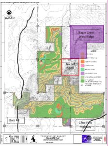
Thornburgh Resort is a 1,970-acre resort being developed to the south and west of the West Ridge development at Eagle Crest Resort.  The current plan states that the resort will consist of 950 lots with 425 overnight lodging units, vacation cabins, three golf courses and resort facilities. The Thornburgh Resort is a destination resort as defined by Deschutes County Zoning Code.

Planning for the Resort began in 2004. In 2008, the proposed development, along with other developments in Central Oregon, slowed due to economic factors.

Deschutes County Board of Commissioners approved a conceptual master plan (CMP) for the resort on May 11, 2006. A map showing the final master plan dated January 22, 2008, is attached. The CMP was appealed to the Oregon Land Use Board of Appeals (LUBA), the Court of Appeals and the Oregon Supreme Court. The CMP was approved in 2009.

The next phase of review required by Deschutes County was the Final Master Plan (FMP) review. The FMP was approved by a county hearings officer on October 8, 2008. Another appellate process followed. The FMP became final on August 21, 2018.

In 2018, the tentative plat application for Phase A-1 was filed and approved by Deschutes County, a decision which has been appealed and is currently pending a decision at LUBA. Thornburgh has obtained final approval of its golf course after completion of appellate review.

The land is currently owned by Central Land and Cattle Company. The person leading the development of the property is Kameron DeLashmutt. Mr. DeLashmutt, who lives in Redmond, acquired the property from his grandparents in 2004, adding further parcels around it between 2004-2006.

The map below has been copied from one of the Thornburgh Resort planning applications. The map has been annotated to highlight the location of the Eagle Crest West Ridge, Cline Falls Highway, Barr Road and a piece of land known as ‘Tax Lot 5300’ that is currently owned by Oregon Department of State Lands, but the Thornburgh resort developers are trying to purchase this land to add it to the resort.

The final plan for the property has been completed and is currently being laid out on the south side of the property with initial roads, drainage and the first golf course.  A new gate has been installed along Cline Falls Highway to serve as the southern construction entrance, but the main entrance will be further north along Cline Falls Highway.  The design of the first golf course is complete with the first nine holes estimated to be built by the Spring of 2023 and the entire course being built later in 2023. The first community will cover 1,240 acres of land and will include a golf course, golf practice area, golf clubhouse, community center, 80 overnight lodging cabins, 300 single family lots and 37 cabin lots.
 
There is a Thornburgh Resort website at www.thornburghresort.com which illustrates the plans for the resort.

Appeals regarding the golf course and lakes approval have run their course but other tentative plan and site plan approvals have been appealed.  Those decisions are pending at LUBA.  According to Deschutes County code and procedure, Thornburgh is authorized to construct everything that has been approved at the local level, even though appeals are pending. Construction is therefore actively underway.

The land owned by the Central Land and Cattle Company being developed into the Thornburgh resort is separated from Eagle Crest by BLM land. The developers are however attempting to purchase an additional 400 acres of land currently owned by the Oregon Department of State Land (DSL).
 
Of these 400 acres, 240 acres are within the boundaries of the planned resort however, Tax Lot 5300 includes 160 acres of hillside on Cline Butte that is outside the boundaries of Central Land and Cattle Company land and directly abuts Eagle Crest.
 
If The Thornburgh developers succeed in purchasing Tax Lot 5300 the Thornburgh Resort and the Eagle Crest Resort will become contiguous. Thornburgh land will come within 180 feet of Eagle Crest homes.
 
The map below shows Tax Lot 5300 is in relation to the West Ridge of Eagle Crest.
Existing walking trails are marked in red.
 

FAQs Continued

First some background on DSL’s mission and purpose.  At statehood, the federal government granted Oregon 3.4 million acres, about six percent of the new state’s land to finance public education.  These lands are State Trust Lands for the benefit of the common school fund.  DSL’s mission is “Ensuring a Common School Fund legacy through sound management of our trust responsibilities and protection of waters of the state.” Trust lands are required to be managed to provide revenue to the Common School Fund, while accommodating other land values. Currently the Common School Fund stands at approximately $2.2B.
 
Presently, the Central Land and Cattle Company leases this land from the Oregon Department of State Lands (DSL) for livestock grazing purposes. The Thornburgh developers applied to purchase these 400 acres of leased land which was appraised at $912,000.
 
As part of the purchase proposal a “due diligence” hearing was held via Zoom in March 2022. Over 280 people requested to speak against the sale of this land. Some represented themselves while others represented organizations. Central Oregon LandWatch spoke against the sale representing over 300 organizations, their press release can be found at
 
 
Recently the Thornburgh developers withdrew their application to purchase these 400 acres of land.
While the purchase request has been withdrawn for now it should be emphasized that this does not mean that the 400 acres of DSL land will be left undeveloped. The Thornburgh developer has a Right of Way over these parcels of land and the local DSL Manager has stated that this Right of Way includes the right to construct roads over the land.

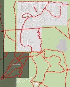
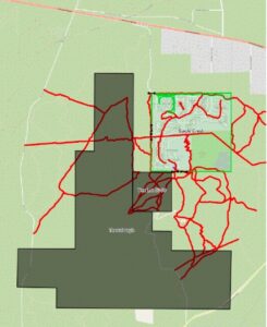
Today there is an extensive network of wild, unimproved, and unfenced hiking trails around the Cline Butte Recreational Area, many of which are directly accessible from Eagle Crest. The map below shows the existing trails around the Eagle Crest West Ridge marked in red.

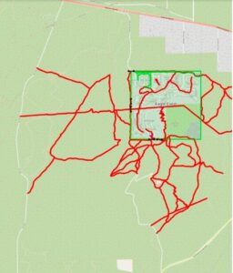
The next map shows the impact of the main Thornburgh development on these trails. The developers have stated that they will create trails within the development, but these will not be the wild, unimproved, and unfenced trails that exist today.

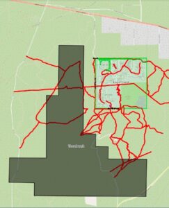
Finally, the map below shows the impact on the trails network if the Thornburgh developers are successful in purchasing g Tax Lot 5300 from the Oregon Department of State Lands (DSL).

As can clearly be seen, the purchase of Tax Lot 5300 brings Thornburgh right up to the fence line of Eagle Crest, closing off the existing recreational and wildlife corridor between the two resorts and severing the integrated set of wild unimproved trails around Cline Butte.
It has been argued that there are many thousands of acres of BLM land close by that remain open for recreation but there are no equivalent areas of hilly Juniper scrub like Cline Butte.

The Thornburgh will include a developed trail system within the resort, but these are expected to be hard surfaced trails. There is currently no commitment on whether they will be accessible to the public.

This is difficult to predict but a recent scientific study:
shows significant impact to mammals from increases in fencing in previously wild areas. There are already concerns about the decline in the number of Mule Deer in Central Oregon and it is probable that this development will have further adverse impact on them.
 
If Tax Lot 5300 becomes part of the Thornburgh development, then a wildlife corridor between the two resorts will be closed off and adverse impact on wildlife is expected.
 
For the last few years, we have seen a Golden Eagle pair nest on the southwest side of Cline Buttes.  The impact of construction activities continuing for years so close to them is unknown.
 
The Oregon Department of Fish and Wildlife have submitted their concerns on the impact to wildlife from the Thornburgh development: Document from ODFW regarding the concerns of mule deer and elk winter ranges.
 
The US Department of the Interior has also submitted concerns: Document from US Department of the Interior

There have been partial sample surveys of some of the areas to be built over but not all. The construction area is considered to have a medium to high risk of containing indigenous cultural resources. The construction is covered by an “Inadvertent Discovery Plan” which defines procedures to be followed if any construction workers realize that they have encountered cultural resources and report them.

The developers have not put a number on their daily usage and report that they are making efforts to develop a water efficient resort.. Other organizations, including Central Oregon LandWatch have estimated the resort’s daily usage as up to 6 million gallons per day. In 2013, State regulators agreed that Thornburgh would be allowed to pump out up to 6 million gallons per day of water.
 
To put this into perspective, in 2021 Oregon Water Utility, the company that supplies Eagle Crest extracted an average of 1.4 million gallons per day.
A newsletter from Central Oregon LandWatch from January 6, 2022, provides information on the situation with groundwater and the aquifer in Central Oregon. You can access the full article at:  https://www.centraloregonlandwatch.org/update/2022/1/6/where-is-the-groundwater-going
They state:
“According to the U.S. Geological Survey (USGS), between 1997 and 2008, groundwater levels in the central part of the basin from Sisters to Powell Butte steadily declined by as much as 14 feet. 
 
USGS determined that the three main causes of groundwater decline are: 
  • Climate
  • Groundwater pumping
  • Irrigation canal piping
Climate is the dominant influence, accounting for 60-70% of the groundwater declines, while groundwater pumping accounts for 20-30% percent of the decline, and canal piping 10%.
 
We know the rapidly growing population in Central Oregon will increase groundwater use. We know that increased pumping from cities, destination resorts, and rural developments will reduce groundwater. As groundwater is depleted and the water table moves further beneath the surface, there are fewer coldwater springs and seeps that will flow into our rivers and streams. The water flowing through the Deschutes River below Lake Billy Chinook will decrease unless groundwater use is mitigated.
 
With foresight into declining groundwater, Oregon passed legislation in 2005 to establish a groundwater mitigation program for this purpose. The policy was meant to require entities that use groundwater (destination resorts, cities, etc.) to replace the water that would be withheld from nearby rivers.
 
Although this policy is currently in place, we are concerned about the ability of the state to enforce it and regulate groundwater use properly.
This is precisely the foundation for the current hearing surrounding Thornburgh Resort, a proposed destination resort, and their groundwater mitigation plan. LandWatch has serious concerns about the mitigation plan proposed by the resort’s developers. 
 
This plan offers to replace the water it pumps from wells with water rights from a nearby ranch, but we believe that these water rights may not generate actual water instream to mitigate the groundwater pumping.”
 
A recent judgement from LUBA on the case against the Thornburgh resort’s water mitigation plan held that even if the mitigating water rights do not represent real water the “paper water” that they represent is all that should be considered.
 
At the beginning of July 2022, the Oregon Water Resources Department issued a Water Application Initial Review to Mr Delashmutt detailing their preliminary determinations. Click to read through a copy of this letter.
 
A recent OPB article also discusses the local water situation in some detail:
A full document on Oregon State’s vision for the future of its water can be found at:
More information on maintaining the Deschutes River basin can be found at:
HikingTrailPic
DeeratWindow
While the Deschutes Basin sits atop a huge aquifer, where the regions total use is a fraction of the annual recharge of the aquifer, there are increasing concerns from people that there are declining groundwater levels, the amount of irrigation water they receive from their irrigation districts will be reduced and they have had to deepen their domestic wells. This is creating a perception of scarcity as discussed below.
 
Declining groundwater levels:
Ground water levels have been declining for some time, which the US Geologic Survey, generally attributes 70% to climate change and the balance to piping of canals and increased water use in Central Oregon.  Where you hear of wells being deepened in most cases those wells draw from a shallow water source that was largely created from the irrigation districts artificially recharging a shallow aquifer over the last 100 years with leaky canals and inefficient irrigation systems.  For example, a report from LandWatch noted the efficiency of Central Oregon Irrigation District patrons was roughly 40% with the balance leaking back into the ground where it recharges that shallow aquifer.  As canals are piped, and lands are removed from irrigation, the amount of water that goes into that shallow source, the many domestic wells that draw from that source receive less water, lowering water levels.  Deep wells such as those at Eagle Crest are generally drilled deep in the lower, regional aquifer that is fed by water from the Cascade Mountains.  These wells are drilled far below the static water level to accommodate fluctuations in drawdown.   
 
Reductions in Irrigation Water Allocations:
There is a great deal of public awareness of irrigation water shortages.  This is a complicated issue, with causes in both climatic and environmental issues that are occurring all at once.  Typically, irrigation districts store water in reservoirs in the winter and release it into the river in the summer to be diverted into irrigation canals to supply irrigation water to customers.  This results in artificial river levels in some stretches of the river year-round.  This fact has steadily been raising the level of concern among both environmental and recreational groups.  That in turn is increasing pressure on the irrigation districts.  The issue of the spotted frog and its federal listing as an endangered species created a whole new rash of issues for irrigation districts.  Environmental Lawsuits led to the implementation of the Habitat Conservation Plan (HCP) for the protection of fish and wildlife that hampered the operations of irrigation districts.  The North Unit Irrigation District that stores water at Wickiup Reservoir, primary habitat of the spotted frog, was severely impacted.  Districts are attempting to re-calibrate operations and allocations, while at the same time trying to ensure that farmers in North Unit have access to water.  The districts are in a period of substantial adjustments as the provisions of the HCP are fully implemented in the coming years.  The negative impact of these adjustments is being exacerbated by several years of drought conditions.  Together, these issues are creating a perfect storm scenario.  
 
So, how do you get water rights in Oregon?
The answer is that “first you must apply for a water right of use. Applications for new water rights of use are made to the Oregon Water Resources Department, the agency that manages public waters in the state of Oregon.  In the Deschutes Basin there is a ban on the issuance of new surface water rights. All new groundwater permits require that the applicant mitigate for 100% of the volume of water requested in the new permit.  The mitigation program is designed to stop further increases in consumptive use of water in the Deschutes Basin and to protect surface flows in the rivers.  To obtain a permit for a new water use, you must terminate a use of the similar amount so that the net consumptive use of water does not increase.  Prior to being able to pump new water the holder of a permit must have provided the mitigation for that water. 
A new water user may also purchase an existing, certificated water rights permit and apply to transfer the water rights to their property.  These are water rights that have already met or are not subject to mitigation requirements.  The public has the right to engage in the water application process through the public comments process. Numerous water conservation groups have been formed to provide public and organizational services as “watch dogs” of this application and management process. Individual water users are encouraged to participate in this public process.
At the time it was being developed, Eagle Crest Resort applied for the water rights to the Oregon Department of Water Resources (OWRD) as part of the entitlement process to develop its Destination Resort. Similarly, Thornburgh Resort has applied to OWRD for water rights, permits and has received approval of a water rights permit to serve the resort.  That permit was extended by OWRD but the extension is being challenged by one opponent of the Resort.  Thornburgh is also seeking to move the point of appropriation and use certificated water rights as a backup source of water while looking for ways to limit overuse of water in the design of the golf courses and resort buildings and will use far less water than if it irrigated its property for agricultural use.
 
Who owns the right to water?
“Landowners typically have the right to use the water as long as such use does not harm upstream or downstream neighbors. The water right, once developed, is a type of property right and is attached to the land where it was established.”
Quasi-municipal and municipal water rights such as those held by Eagle Crest, Thornburgh and Oregon cities and utility companies are personal property rights that are not appurtenant to specific acres of land.  Rather, they may be used anywhere within the water supplier’s service area.  For example, when you sell your home at EC you do not sell the water rights for that home.
 
Who owns the water?
“Oregon law provides that all water is publicly owned. With only a few exceptions, a water right is required before any person (including a city, business, or other entity) may divert water from its natural course and put it to “beneficial use.”
 
What is “Prior Appropriation”?
“The term refers to the general principles of water law adopted in Oregon and throughout the western United States more than a century ago. The doctrine of Prior Appropriation evolved in the law to promote settlement and development of the West. The basic concept is that people are encouraged to put water to “beneficial use” by taking it from a stream and applying it to the land. The system is basically one of first come, first served. The first person to obtain a water right on any given stream will be the last person to be shut off in times of shortage. The “senior” water right holder is entitled to take all the water needed and allowed under his/her water right before the next junior water right holder is served.” Currently there is a growing awareness that the North Unit Irrigation District is short of water.  This is because NUID is a very junior user that gets the tail end of the irrigation water diverted, by right, from the Deschutes River.
Thornburgh, like Eagle Crest, is an Oregon Destination Resort.  Sunriver, Pronghorn, Black Butte and Brasada Ranch also fall into the category.  Basically, the law allows development in areas outside cities that would normally be restricted to agriculture or forest.  Here are a few of the pertinent standards from ORS 197.445:
  • Resort must be located on a site of 160 acres or more
  • At least 50% of the site must be dedicated to permanent open space
  • At least $7 million must be spent on improvements for on-site developed recreational facilities and visitor-oriented accommodations
  • Visitor-oriented accommodations, including meeting rooms, restaurants with seating for 100 persons, and 150 separate rentable units for overnight lodging shall be provided.

The following chart from the original application shows the living units built out in each phase. 

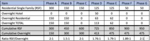
Thornburgh has received County approval of a 2.5:1 ratio of single-family homes.  The only potential impact of this change as approved is to allow Thornburgh to build fewer overnight lodging units. It should be stressed that the developer may apply to make changes to the FMP at any time and so these numbers are not guaranteed.

As the development progresses, there will be a need for tentative plans and site plans, notwithstanding the fact the FMP has already been finalized. Site plans would, of course, be necessary to show the footprint of the building on the site, where utility easements would be located, etc.  That level of detail is not contained in the FMP.

Plans call for a second community to be located on the west side of Eagle Crest with access from Eagle Crest Boulevard off Highway 126.  This initial access road already exists.  This village has approval for a planned residential community comprised of one golf course, a 50-room resort hotel, resort rental area, recreational lake, a lake/boating clubhouse, and individually owned residences.  It will include 730 acres of land.

Yes, Thornburgh resort owners and visitors have an easement to share the existing road into Eagle Crest from Highway 126. This road is through BLM land through an agreement that RECOA has. The road  is maintained by RECOA today. To date RECOA and the Thornburgh developers have not had discussions about sharing maintenance costs for the shared portion of the road.

The Ridge at Eagle Crest has some 1,750 lots on around 1,200 acres.  According to the approved FMP Thornburgh will have some 950 lots on 1,970 acres.

Currently, we do not know. Local Realtors believe that the average price of Thornburgh homes will be higher than that of Eagle Crest homes.

It is anticipated that the golf course and other amenities will be open only to resort guests and owners. The developers say that after the second course is complete, the resort management will determine whether to offer private, semi-private or public use of that course. 
 
Over the last 17 years there have been some 50+ appeals and lawsuits of Thornburgh approvals.  Other opponents object to the development as a whole and most recently there is opposition to the sale of 400 acres to Thornburgh by the Department of State Lands.  The approval process for a resort community like Thornburgh as well as the sale of additional state lands is a complicated process encompassing laws on land use.  
 
A web search of “Thornburgh Resort Opposition” leads to numerous articles with information about those in opposition.  The biggest single reason seems to be water availability in an era of drought, although there are concerns about habitat for fish and wildlife.  Here are the websites for the two groups who have indicated their opposition.
 
Central Oregon LandWatch (COLW) www.centraloregonlandwatch.org
On their website, COLW, state that they work “to create well-planned cities and protect wild, open spaces across the region.”  They further state they “use the power of federal and state law to defend and protect the natural environment.”  
 
Oregon Land and Water Alliance (OLAWA) . www.olawasisters.org/ 
On their website, OLAWA states that they are “advocates for protection of land use laws and sustainable water policy” and that they actively monitor, analyze, and raise awareness of issues “affecting residents and visitors in Sisters Country.” They list Thornburgh Resort as one of their key issues.
RECOA has never taken a position on the main Thornburgh development. RECOA owners are encouraged to educate themselves on the subject and make their own determination as to their views on the resort.
 
At the RECOA Board Meeting on February 24, 2022, the six board members present unanimously approved a resolution in opposition to the BLM/DSL proposed land sale (as discussed in above) that stated, “RECOA believes that the proposed sale of Tax Lot 5300 in the Cline Buttes Tract by Oregon State Land to the developers of the Thornburgh Resort is not in the best interests of Eagle Crest homeowners.”  
 
The full statement was submitted during the public hearing process and is included in the board minutes and can be accessed on our website. Individual RECOA owners also submitted letters through that same process.

When asked, they aren’t aware that any conversations have occurred.  However, they wouldn’t preclude conversations in the future at some point.

According to the Oregon Department of Land website, on July 29, 2022, Mr. Kameron DeLashmutt (developer of Thornburg Resort) withdrew his request for purchase of 6 tax lots, including Tax Lot 5300, adjacent to Eagle Crest Resort West Ridge. He states in his letter “…I am no longer interested in the land at this time. That may change but at the present that is my position.”

While the purchase request has been withdrawn for now it, this does not mean that the 400 acres of DSL land will be left undeveloped. Central Land and Cattle (Thornburgh developer) will continue to lease the tracts. They have another 10 years remaining on their lease. The Thornburgh developer has a Right of Way over these parcels of land and the local DSL Manager has stated that this Right of Way includes
the right to construct roads over the land.

Yes, the Traffic Impact Analysis (TIA) study for Thornburgh Destination Resort was completed in 2005 and is part of the land use permit record.  The land use application, which includes the TIA, has been repeatedly appealed and both Oregon Department of Transportation (ODOT) and Deschutes County have not required the TIA to be redone. The TIA indicates a maximum of 517 weekday pm peak hour trips would be generated by the development. The Thornburgh Resort Conceptual Master Plan can be viewed by clicking here.  The TIA starts on page 52.

Improvements will be made at US 20/Cook-OB Riley; Thornburgh Resort entrance/Cline Falls; and OR 126/Cline Falls.  The developer will be required to construct a left-turn lane for north-bound Cline Falls Highway traffic at the entrance to the Thornburgh Resort. As of this posting (October 2022), the construction plan for the turn lane had not yet been submitted to Deschutes County Road Department.

Deschutes County Community Development Department is not aware of any obligations for the developer to construct additional improvements on Eagle Crest Blvd under existing land use approvals. Improvements at OR 126/Eagle Crest Blvd intersection were completed under requirements for Eagle Crest.
 
Thornburgh Resort will pay for the improvements at the site entrance at Thornburgh Resort entrance/Cline Falls Highway.
 
ODOT has a project identified for the US 20/Cook-OB Riley intersection. Thornburgh Resort will be required to contribute to this improvement based on a proportion of the volume of traffic they are adding to the intersection.
 
The County does and will collect transportation system development charges (SDCs) from homes built at the Thornburgh resort as well as for any golf courses.  The County then uses those SDCs to fund improvements to the County road network.  The SDCs are not geographically tied to the area where they were collected; in other words, SDCs collected in South County could be spent on modernization (construction) projects on County roads near Thornburgh and vice versa.
 
 
Document Authors and Sources of Information
This document was developed at the request of the RECOA board.  Three owners worked on the answers to the questions in this document:  Monty Knittel and Robert Sharpe, on behalf of the RECOA board; Cindy Phillips, a retired land use attorney and municipal judge; and Butch Henry, current chair of the RECOA Utilities Committee with experience in water issues.  Their process included contact with the Deschutes County Planning Department to access and review documents, reviewing state and federal laws and processes, and meeting with Thornburgh Resort representatives.  There were also conversations with realtors, numerous owners, a land use consultant, and resort management regarding the process of the Thornburgh Resort and any potential impact.
 
last revised date October 28, 2022
9. Thornburgh 4th photo